By Greg Gresham
North Alabama Civil War Round Table
A few weeks ago, I wrote about the skirmish that pitted Union Cavalry, under Gen. Datus Coon against generals Frank Armstrong & Abraham Buford’s Confederate cavalry in the Butler Creek Valley, at its junction with Shoal Creek. This skirmish took place shortly before the Confederate Army of Tennessee marched north on its ill-fated Franklin-Nashville campaign. Not long after I posted the story online, I was able to visit the site of the battlefield, along with the “Hidden Ford” location, which allowed me to match the written story with my own personal observations.
If you missed the story, you can review it in my previous blog post.
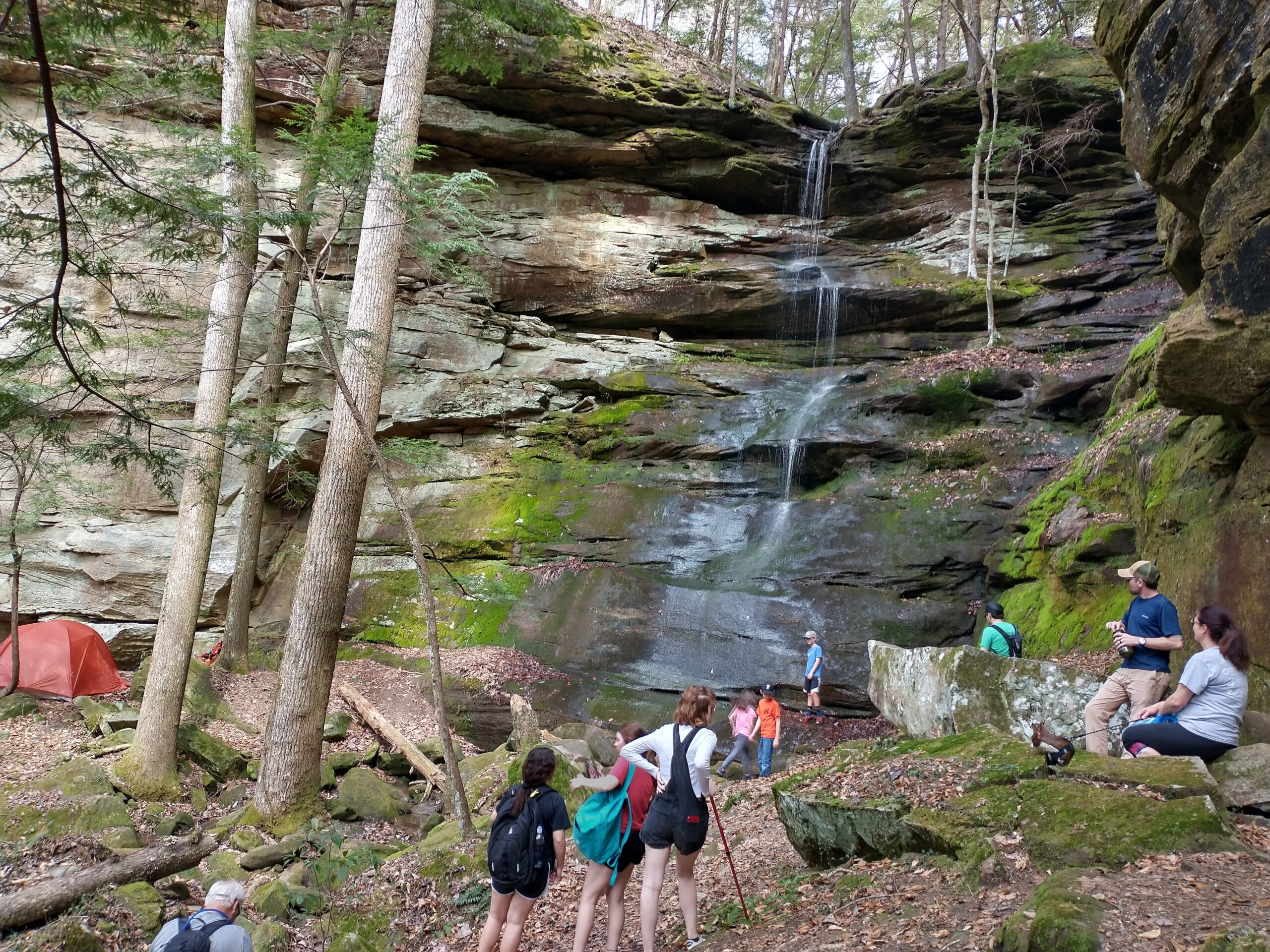
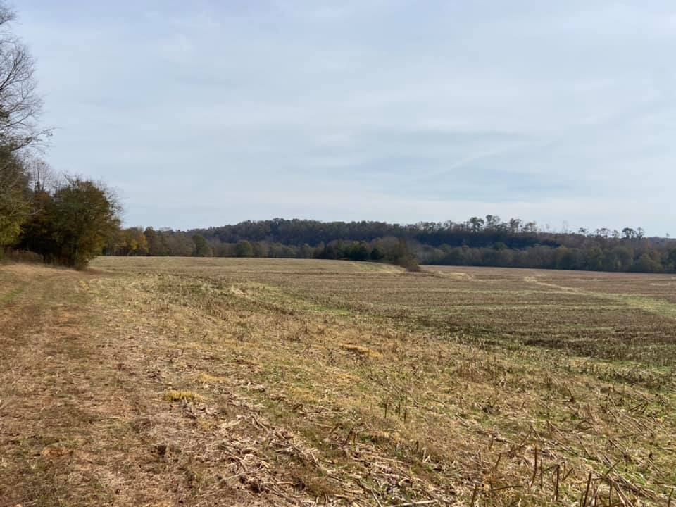
The 1.5-mile trek down the valley allowed me ample time to view the surrounding landscape to try to visualize the events of that day long ago. The “high bluffs” on both sides of the valley were quite evident & played a prominent role in the Federal efforts that repelled the flanking attacks of the Confederates. Nearing Shoal Creek, the valley was clear of any stands of timber & in full agricultural use. Other than a camp house at the creek plus a few deer stands, the landscape appears to have changed very little in the past 156 years.
Upon reaching the ford site, certain aspects of the several stories I had read about the skirmish became much clearer.
First, finding a useful military ford on Shoal Creek wasn’t easy. Shallow water, at Shoal Creek’s normal pool, is fairly ample. But, a good ford, besides being shallow, must be accessible not only to foot and horse traffic, but also for heavily laden wagons and–in this case–a fully complemented artillery battery. Towering bluffs, 100 to 200 feet high, usually dominate one side or the other of Shoal Creek along its crooked course. Even when a towering bluff isn’t present, the creek bank on one side may still have a very steep change in elevation, thus making shallow water in those spots unfeasible for a ford.

Second, shallow water doesn’t always run the shortest distance from creek bank to creek bank. It’s common for a wader to save time by zigzagging to avoid deeper water when crossing a makeshift ford. An ideal ford will be almost a perfect 90 degrees to the stream’s flow, allowing the traveler the least amount of time in the water possible. Rarely does any ford have a perfectly straight path. Usually the path zigzags or runs more into or with the stream than across. This can make a ford quite hazardous.
The Savannah and Wolf fords above Butler Creek, along with the Cowpens Creek ford further downstream, had ideal conditions for a ford: shallow water, nearly perpendicular to the creek’s current & bounded on both sides by gentle sloping creek banks. As I scanned Shoal Creek and its creek banks at the site of this “Hidden Ford,” as one Union soldier remembered it, I could see that it wasn’t perfect.
The 1930s agricultural map that gave the ford a name–Section Ford–depicts the ford crossing at a severe angle into the creek, perhaps greater than 45 degrees. From the high bluff above, one could see most of the shallow shelf that defined the route across the creek, and it appeared to accurately match the map. Thus, the two crossing points, on the east and west banks, were possibly 200 to 250 yards apart even though the creek was perhaps only 100 to 120 yards wide at the shortest point.
While scanning the far bank–a somewhat steep 4-8 foot high but vehicle-accessible opposite bank–I realized that the bank upon which I was standing was nothing of the sort. It was a good 20 foot, perhaps even 30 foot higher than the creek, and steeped significantly. A man and a horse could carefully descend it, but not a horse-drawn wagon.
Pondering how Gen. Datus Coon’s brigade could have escaped via the ford, I searched for a “easy” way to the water’s edge. I saw a narrow “washed out ravine” that I had noticed earlier. At first, it was apparent that this “ravine” would be an easy path downward even though a tree had fallen across it. However, on further observation I realized that the ravine was not made from water erosion because there was no natural path of rainwater. I then realized that this must have been the path that that wagons used to access the creek bank, and I immediately remembered a reminiscence of Richard W. Surby, quartermaster of the 7th Illinois Cavalry:
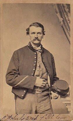
“Orders were given for the train and artillery to turn up the valley of the Little Butler, accompanied by the 6th Illinois cavalry, Major Whetrish, commanding, who was instructed to take all the spades and make a crossing on Shoal Creek, as this was the only place to escape from a well-devised trap of the enemy.”
It had not struck me when I first read this passage related to the part about the “spades.” Now it was abundantly clear that it wasn’t just the spades but it was “all the spades,” as they were all needed, and quickly, to produce the desired sloping ramp to the creek that would allow the wagons and artillery to use the ford. This was no small task and much more impressive than the passage would lead one to believe. The result of those “spades” produced a suitable ramped pathway to the creek’s edge that appeared to be at least 8-10 feet deep at the point of maximum excavation and perhaps 25-30 feet in total length. It was barely wide enough for a wagon to fit.
Later, Surby discussed the story further:
“The enemy seemed intent only on capturing the whole command, and no doubt felt confident of the same. Each regiment fell back alternately and formed lines for two miles until they reached Shoal Creek and found, to their great surprise, the 6th Illinois, pack train, artillery, and ambulances all safe on the other side, and the regiment dismounted to cover the crossing. A lively skirmish was kept up by the rear-guard while the command passed down the steep, miry bank by file, obliquely, one hundred and fifty feet. The mortification and apparent chagrin of the Rebels, when they found their prey had unexpectedly escaped their snare, was made known by their hideous yells such as rebels only can make. By dark the command had returned to the same place they left in the morning, with a firm belief that Butler Creek was becoming very unhealthy. The day had been one of incessant rain.”

This passage spoke of the danger of a soldier having his back against a rain swollen, potentially unfordable creek, and the relief of finding his reserve, with artillery, safely across the creek, helping defend his crossing.
The passage also speaks of the trek down the “steep miry bank.” It was done “obliquely” and by “file.” Thus you get a sense of the steepness of the creek bank & the wet weather, as they went 150 feet, in an indirect or angled way, to drop the 40 feet or so to the creek’s edge. It’s also possible that the author’s company was on the Union right flank, atop a bluff 150 feet high above the creek, which would have put him directly perpendicular to the far bank of the ford. To access the other side, he would have had to drop 150 feet obliquely to get to the near side of the ford.
The trip to the “Hidden Ford” had been a truly educational experience. It gave me a sense of the terrain in those Union soldier’s reminiscences, and it made their stories much more meaningful. As I walked back to my truck, hoping for my own uneventful fording of Butler Creek, I thought of the contrast of this day compared to the one some 156 years ago. Today, perhaps only a handful of people are in the quietly serene 2 or 3 square miles at the end of the Butler Creek Valley versus the 3,000-4,000 cavalrymen, and their horses, here that day during the Civil War. As I took one last look across the valley, the bluffs towering on three sides of the natural amphitheater, I could imagine the sounds of battle, horses galloping, men yelling, officers barking out commands, etc., and I wondered how loud those “hideous yells such as rebels only can make” must have been as they echoed bluff to bluff in the Butler Creek valley.
Blog-post author Greg Gresham is doing stuff he likes to do after retiring from 33 years in the pulp & paper industry. When he’s not golfing or enjoying being a grandfather, he digs into historical research with an emphasis on Civil War era local history. Sometimes he stumbles on intriguing yarns from years ago, or–with a little luck–he solves a mystery or two. Those, he says, make good stories.